
"It's two thousand miles I roamed
Just to make this dock my home
Now, I'm just gonna sit at the dock of the bay..."
- Otis Redding (Lyrics to Sittin' on the Dock of the Bay)
Locale: Point Pinole Regional Shoreline, Richmond/Pinole, Contra Costa County, CA
Date: Sunday, September 28, 2008
Price: $3
Duration: approx. 5 miles (2.5 hours)
Activity Level: Easy
All in All: A diverse and easy hike that is available for bicyclists, hikers, strollers, fishermen and picnic-ers.
Rating: ***1/2
Maps & More Info: http://www.ebparks.org/parks/pt_pinole

Hiking trails this close to Chevron oil refineries? Right next to Richmond? And near the interstate? These three facts are a few reasons why the park is mainly utilized by locals to Contra Costa County. And all three facts are no reason to stray from it either. Getting there is quite simple, from I80 (coming from SF) take the Richmond Pkwy exit, turn left at the light and follow about two miles until the Giant Hwy turn. Turn right here and follow the signs to Point Pinole. It'll eventually be on the left with a big sign, kiosk and lot.
I actually live on the northern edges of the San Pablo Bay. Our apartment complex had a small picnic area that overlooks the bay in fact. I couldn't think of a better song then Otis Redding's posthumous released "Sittin on the Dock by the Bay" to encapsulate any sizable body of water and its view here. Since this was our first place since moving 2,000 miles away from home, again, the lyrics are symbolic.
 Like many of the hikes we've trekked this past year, many are quite historical. This hike was once a dynamite base. In the 60's, it was actually contemplated for NASA's Mission Control center which was eventually based in Houston. This was all interesting to me - and all of it can be found in the brochure. The decision of NASA's to not build Mission Control at the shoreline may have been a relief to natives but perhaps not as well.

The hike is fairly easy. There are few if any elevation changes on the trails and poles are quite unnecessary. Start from the lot towards the bridge that goes over the railroad tracks. After the bridge get on Bay View trail on the left. Oil refineries will be on the left, Mt. Tam on the right. As you walk closer to the water you will see many signs warning to keep out of it. It's a resource preserve and dogs and humans are not allowed to go into the water no matter how hot the day may be. After about two miles on Bay View Trail comes my favorite park of this hike. Take the narrow trail on the left down to the fishing pier. The pier is 1/4 mile long and if you love to fish this may or may not be a great place. No license is needed but take note of the signs for which fish you are not allowed to take home with you. Also note that eating only a couple meals of the fish a month is advisable due to mercury and other chemicals the fish may take in.
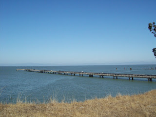

As you walk down the pier, you will notice on the right the old fishing pier. There were at least a dozen or more people on the pier fishing as we strolled. My boyfriend asked a man if he caught anything, "Not a thing all day," he replied. As we reached the end of the pier, the contrary seemed the be occurring. Just in time, we saw a man pull out a sting ray - barb and all! This was something I'm not used to seeing everyday. A few minutes later, a man from the same party caught two fish on the same line. Fishing, something I haven't done since moving from Wisconsin to Minnesota over six or seven years ago. It was something I used to enjoy in local lakes and rivers despite my distaste for most fish and seafood. Time to finish the hike, we thought as we stopped briefly for a snack.
 Leaving the pier, you'll pass the bus depot. Yes, there's a bus depot in the middle of the park for those who fish and would like a ride to and from the pier. It's a dollar to go the mile or two back. Turn left onto Owl Alley trail. You shouldn't be on the blacktop anymore. The rest of the hike has a more Sunday picnic feel to it. You'll pass many benches and grills and even a pond. After a .25 mile, turn onto Marsh Trail. After another .48 miles, turn right on Cook's Point trail.
 Planes, trains and automobiles... and boats - we saw these quite frequently on our pleasant little hike. Not much wildlife seen on this hike but I didn't care. It was enough to suffice my intermittent addiction to the great outdoors. For some, Pt. Pinole may not be isolated enough and may not have the awe that Point Reyes has but whether you are coming or going, it'll always be there for people to enjoy.

Just to make this dock my home
Now, I'm just gonna sit at the dock of the bay..."
- Otis Redding (Lyrics to Sittin' on the Dock of the Bay)
Locale: Point Pinole Regional Shoreline, Richmond/Pinole, Contra Costa County, CA
Date: Sunday, September 28, 2008
Price: $3
Duration: approx. 5 miles (2.5 hours)
Activity Level: Easy
All in All: A diverse and easy hike that is available for bicyclists, hikers, strollers, fishermen and picnic-ers.
Rating: ***1/2
Maps & More Info: http://www.ebparks.org/parks/pt_pinole

Hiking trails this close to Chevron oil refineries? Right next to Richmond? And near the interstate? These three facts are a few reasons why the park is mainly utilized by locals to Contra Costa County. And all three facts are no reason to stray from it either. Getting there is quite simple, from I80 (coming from SF) take the Richmond Pkwy exit, turn left at the light and follow about two miles until the Giant Hwy turn. Turn right here and follow the signs to Point Pinole. It'll eventually be on the left with a big sign, kiosk and lot.
I actually live on the northern edges of the San Pablo Bay. Our apartment complex had a small picnic area that overlooks the bay in fact. I couldn't think of a better song then Otis Redding's posthumous released "Sittin on the Dock by the Bay" to encapsulate any sizable body of water and its view here. Since this was our first place since moving 2,000 miles away from home, again, the lyrics are symbolic.
 Like many of the hikes we've trekked this past year, many are quite historical. This hike was once a dynamite base. In the 60's, it was actually contemplated for NASA's Mission Control center which was eventually based in Houston. This was all interesting to me - and all of it can be found in the brochure. The decision of NASA's to not build Mission Control at the shoreline may have been a relief to natives but perhaps not as well.
The hike is fairly easy. There are few if any elevation changes on the trails and poles are quite unnecessary. Start from the lot towards the bridge that goes over the railroad tracks. After the bridge get on Bay View trail on the left. Oil refineries will be on the left, Mt. Tam on the right. As you walk closer to the water you will see many signs warning to keep out of it. It's a resource preserve and dogs and humans are not allowed to go into the water no matter how hot the day may be. After about two miles on Bay View Trail comes my favorite park of this hike. Take the narrow trail on the left down to the fishing pier. The pier is 1/4 mile long and if you love to fish this may or may not be a great place. No license is needed but take note of the signs for which fish you are not allowed to take home with you. Also note that eating only a couple meals of the fish a month is advisable due to mercury and other chemicals the fish may take in.


As you walk down the pier, you will notice on the right the old fishing pier. There were at least a dozen or more people on the pier fishing as we strolled. My boyfriend asked a man if he caught anything, "Not a thing all day," he replied. As we reached the end of the pier, the contrary seemed the be occurring. Just in time, we saw a man pull out a sting ray - barb and all! This was something I'm not used to seeing everyday. A few minutes later, a man from the same party caught two fish on the same line. Fishing, something I haven't done since moving from Wisconsin to Minnesota over six or seven years ago. It was something I used to enjoy in local lakes and rivers despite my distaste for most fish and seafood. Time to finish the hike, we thought as we stopped briefly for a snack.
 Leaving the pier, you'll pass the bus depot. Yes, there's a bus depot in the middle of the park for those who fish and would like a ride to and from the pier. It's a dollar to go the mile or two back. Turn left onto Owl Alley trail. You shouldn't be on the blacktop anymore. The rest of the hike has a more Sunday picnic feel to it. You'll pass many benches and grills and even a pond. After a .25 mile, turn onto Marsh Trail. After another .48 miles, turn right on Cook's Point trail.
  Planes, trains and automobiles... and boats - we saw these quite frequently on our pleasant little hike. Not much wildlife seen on this hike but I didn't care. It was enough to suffice my intermittent addiction to the great outdoors. For some, Pt. Pinole may not be isolated enough and may not have the awe that Point Reyes has but whether you are coming or going, it'll always be there for people to enjoy.

1 comment:
Hi. I found this blog by googling for people who might be interested in improving the walking environment in Solano County. I am looking for motivated people in Solano County who have creative ideas on activities to increase the amount of walking in their community. This could mean people who are interested in starting a new walking group, an one day activity that promotes walking in some way, such as a scavenger hunt, or getting shoes for people in the community without comfortable walking shoes. If interested, please email me at: hcho@solanocounty.com and I will add you to my distribution list for an application for a minigrant once the funds for the mini-grant is available.
Post a Comment